jueves, 20 de diciembre de 2012

3º British: Natural Environment (relief)


Here you have the link of the Unit 2 Natural Environment (Part 1): Relief and landscape processes (15 pages...)

There is also an optional part: the Glossary. You can print it or not, but remember that in the exam it will be a question of vocabulary...

As you can see, the first point of the theoretical unit is about tectonic plates and the continental drift. Continental drift is the theory that 200 million years ago there was a single continent called Pangea on the Earth. You can watch a video from National Geographic. As if you want more information about tectonic plates, there is another video, from BBC.

Another topic that frightens yet excites every geography student (go on, admit it), natural hazards and disasters have been very much in the news over the past 12 months. As an example, using Google Technologies, you can see a map of earthquakes happened during the last week…

NEW! Here you have the link to the "How to solve Case Studies" presentation. You can print it or not, as you prefer; it is just a guide for helping you in the activities of the following weeks.

lunes, 17 de diciembre de 2012

1º British Debate: 2012 The end of the World or the beginnig of a new Era?


2012 is believed to be the year to witness the end of the world… Before the debate in class, watch this video on Youtube (8 minutes).


The Mayan’s comprehension of time, seasons, and cycles has proven itself to be vast and sophisticated.  The Maya developed 17 different calendars.  The particular Mayan Calendar that has steadily drawn global attention since 1987 is called the Tzolk’in or Cholq’ij.  

The Mayan Dooms Day (Dec. 21, 2012) based on that calendar is in fact a rebirth, the start of the World of the Fifth Sun, a new era when peace begins, and people live in harmony with Mother Earth.

Why? Because at sunrise on December 21, 2012 for the first time in 26,000 years the Sun rises to conjunct the intersection of the Milky Way and the plane of the ecliptic.  This cosmic cross is considered to be an embodiment of the Sacred Tree of Life and that, according to Mayan’s culture, will open a channel for cosmic energy to flow through the earth, cleansing it. The key is notfocusing on death, but on the rebirth, the new chance of doing things well!  


Questions for the debate:

  1. Where are the Mayans from?
  2. Do they still exist? What happened to them?
  3. How do we know about them?
  4. What is the date that has been predicted?
  5. What special day is this every year on the normal calendar?
  6. Is there consensus about the significance of this date?
  7. At which special Mayan archaeological site can you watch the sun rise?
  8. How many tourists are expected to come to Mexico because of the prophecy?
  9. What other predicted apocalypse dates have passed recently without event?
  10. We usually use base 10 for counting, but what base counting system did the Mayans use for their calendar?

miércoles, 12 de diciembre de 2012

3º British: Changing the maps


We have learnt in class that exist several ways to represent the Earth in a flat format. They are known as planimetric maps.


The most common one is the cylindrical model, and all of us in the Western world are used to see the Earth in this way:


However, have you ever thought how the world map is for a Japanese person? Well, the map changes a little bit because Japan is in the middle:


And what would happen if we change the map proportions? In this brief extract from the "The West Wing TV serie" (3:49 minutes, from season 2 – episode 16), it is explained in a high-level way the differences between the Gall-Peters projection and the Mercator projection. These differences were the reason of important disputes in the past…

Have a look to the video and after that please answer the following questions (When you finish them, you have to send it by email to: blogeducativo08@gmail.com):

-         In what century did Mercator create his first map?
-         What problems or defects does Mercator’s map have?
-         In what century did Peters create his projection?
-         What was Peters expecialized in?
-         What arguments are used in the video to defend the Peters projection?
-         What problems or defects does Peters’ map have?
-         What projection is used by Google Maps? Why?
-         Opinion: what do you think about this maps manipualtion? Why?

If you need more help, you can also watch this video about Map projection and GIS (only 1 minute)


miércoles, 5 de diciembre de 2012

4º British: Black America


Here you have the presentation of "Political evolution of Black America". There is not exam of this unit, but it will be a good idea read the famous speech "I have a dream" of Martin Luther King (1963). 

You can also watch the speech on youtube if you prefer (about 15 minutes).

lunes, 26 de noviembre de 2012

1º British: Webquest on the climates of Spain


Spain is a privileged country, enjoying a wide variety of climates, and precisely this variety makes possible amazing contrasts between the different landscapes.

Each group must choose a type of climate (continental, oceanic, mediterranean, subtropical or mountain) and complete a study on it, including in which areas of Spain is located, what features it has (temperature, rain…), how is its landscape...

Each group should prepare a Word document, which can also include maps and photos of the chosen climate landscape.

When finished, make sure you have signed the document (name and grade) and saved it as a .Doc file (to avoid problems with different versions of Word), and please send it to the email address blogeducativo08@gmail.com

To start your research, you can check the following websites:

In English: you can read many information about Spanish landscapes and Iberian wildlife tour.

In Spanish you have two interesting interactive websites at Libros vivos España and Libros vivos Europa, by SM.

Good luck with this task!

viernes, 23 de noviembre de 2012

4º British: Unit 6 USA


Here you have the link of Unit 6: Independence and Civil War of USA. As I told you in class, there is not exam of this topic, but you must do the following Weekly Work.


In addittion, you can watch on youtube two scenes of the serie “John Adams”.

John Adams is a 2008 American TV miniserie chronicling most of President John Adam's political life and his role in the founding of the United States. The miniserie was directed by Tom Hooper and the screenplay was based on the book "John Adams" by David McCullough several awards. 
             
Here are the links (bads news: there are traslated to Spanish):


miércoles, 21 de noviembre de 2012

4º British: French Revolution Poll

Here are your works of the French Revolution. Some of them are really interesting, others are more conventional... Now you can vote! Which one do you prefer? You have the works in a list below. You can vote in this link.

The marks have already been laid, so your opinions will have no influence on the outcome.

PD. To avoid problems with the different versions of Office, I have converted all of them into pdf’s. I also deleted your names, following the rules of data protection (you are under age…) for online publications.


Enjoy the reading!


Calonne
Diary of a soldier
Fencius the sans-culotte
Fouche
Guillotine
Ivan’s diary
Journal de France
Louis XVI (A)
Louis XVI (B)
Luke Moreau
Marat
Olimpe de Gourges
Raducu’s diary
Robespierre
Sieyes (A)
Sieyes (B)

martes, 20 de noviembre de 2012

3º British: how to calculate gradient


Watching this video from youtube, you can review how to calculate the gradient of a slope

It is easy!

martes, 6 de noviembre de 2012

3º British: Mapping the world


Here you have the link to download the Unit 1 of Geography: Maps and Cartography. As I told you in class, it is a very heavy file (244MB), so be patient... And if a message from Google is displayed about not being possible to check if the file has viruses, please ignore it and download the file anyway; that is again because the file is really big and the file is 100% free of virus.

And here you have the Weekly Work: Londonderry topographical map.


Adapted from Grant Kleeman (Cambridge University Press)

lunes, 5 de noviembre de 2012

4º British: Unit 5 Unifications of Italy and Germany


Here you have the link for the new unit: Unifications of Italy and Germany

And you also have to print the new Weekly Work (units 4 and 5). I will give you the deadline at class.

You can also watch this video with a quick review (3:30 minutes) of both unifications processes. If you prefer, you can download the detailed presentation of class about the processes of unifications... 

viernes, 26 de octubre de 2012

4º British: French Revolution Webquest


The first webquest of the year has two parts: do an historical research... and be creative!

Your task is to take on the role of a French citizen during the time period of the French Revolution. After deciding on your character, you should pick two stages of the Revolution in which your character would have participated.

Your ultimate goal is to write a 4-page narrative from the perspective of your historical figure (you can also add photos). Because it is primarily a work of fiction, you can be creative with some of the details. However, the overall story must be accurate with respect to the events of the French Revolution. You can read more details in the webquest page.

You have to send it by email to: blogeducativo08@gmail.com. This work will be part of the score at the end of the term. If you fail to finish them or you do it out of date (Monday 19 November), the mark will be a 0 for that work.


Adapted by: Michelle Cottrell-Williams (Wakefield High School)

lunes, 22 de octubre de 2012

1º British: Playing with Google Earth


We already know the cartographic projections and the different kinds of maps; we have also worked with coordinates and scales in maps of paper… Now we are going to work with Google Earth. Most of you surely already know it, so today’s exercise should be easy ;-)

But before start, we need to install it! You can do it quickly from this link to the free version:

Have you finished? Now to start using it we need to know its different areas. Have a look to the next image and localize each area in your computer:


Have you find out what all the areas are for? Let’s work with them! All the activities are mandatory, OK? Make sure you write your answers in a Word document (making sure you save it with the .doc extension). You can include images from the exercises, using the option “Save image” from the “File” menu and pasting them into the Word document. Once you have finished all the work, send it by email to: blogeducativo08@gmail.com


Activity 1

Here you can see a list of coordinates… You have to find out what city each one of them belongs to. But take care with one thing! There is a condition when completing this activity: you cannot use the Google Earth searcher; that would be cheating! Remember that we are here to learn and not to compete, OK?

You must use the option “Lat/Lon Grid” from the “View” menu to display the meridians and the parallels and their numbers, and from there you must try to identify the element. For example:


You must identify almost five cities from the following list. Good luck!
Latitude
Longitude
43º.22’ N
5º.50’ O
40º.57’ N
5º.40’ O
40º.24’ N
3º.41’ O
41º.23’ N
2º.11’ E
52º.31N
13º.24E
47º.22’ N
8º.32’ E
40º.43N
74º.00O
10º.00S
55º.00O
33º.51’ S
151º.12’ E
35º.29’ S
62º.58’ O

Activity 2: The relief of Spain

Here we will try to identify several items from the Spanish relief (ranges, plateaus…) and their main characteristics. In fact, you should search for: Pyrenees, Teide, Peña de Francia, North Plateau and Guadalquivir’s Valley.

To “see” them you must follow the next steps:
  1. Activate the “Terrain” layer (“Layers” section) that allows you to observe the relief in 3D (spite of a flat photography).
  2. Change the terrain’s viewing angle to see the relief from another perspective, different to the normal top view.


Activity 3: Measure the Strait of Gibraltar

This exercise is the easiest one of all. It will help you to learn how to measure (in straight line) a distance with Google Earth.  To do that, you should allocate yourselves in the south limit of the Iberian Peninsula and measure the distance to the African coast. That can be done using the “Measure/Line” option in the “Tools” menu. For example:


miércoles, 17 de octubre de 2012

3º BRITISH: Webquest and Presentation: Baroque’s artists


The first webquest of the year has two parts: do a research... and a presentation in class!

You have to choose a Baroque artist (see the list below) and a study his/her work. The file (PowerPoint) should include between 10 and 30 slides. Besides his/her artworks’s photos, you must include the following sections:

  • Brief biography of the artist (between 10 and 15 lines).
  • Three masterpieces by the artist, with an explanation (the title, the “mecenas” or art collector, what does it mean, what is it important for...).
  • Conclusions: opinion from all members of the group about the artist and the work.
  • Webgraphy (links to websites consulted) and Credits (which section did each team member).

You have to send it by email to: blogeducativo08@gmail.com. Then, you will have to present the results in class! Each group will make a small presentation (about 5-8 minutes) and remember that ALL the members of the team has to talk. But don’t panic: here are some tips for public speaking.

Here is the list of Baroque’s artist you can choose from:
  1. Architects: Bernini, Borromini, Carlo Maderno, Mansart, Churriguera.
  2. Sculptors: Bernini, Duquesnoy, Gregorio Fernández, Martínez Montañés.
  3. Painters: Caravaggio, Artemisia Gentileschi, Rubens, Rembrandt, Velázquez, Georges de la Tour, Canaletto, Veermer, Van Dyck, Murillo, Mary Bayle.
And here are some links where you can start:

This work is compulsory and it will be part of the score at the end of the term. If you fail to finish them, you do it out of date or you don’t do the presentation, the mark will be a 0 for that work.

lunes, 8 de octubre de 2012

4º British: Unit 4 French Revolution (The crisis of the Ancien Régime)


Here you have the link to the next theoretical unit (Number 4): The crisis of the Ancien Régime, that includes the French Revolution, the Napoleonic Empire and the liberal revolutions of 1820, 1830 and 1848. 

You can also download the glossary and the notes of Romanticism (the "art of revolutions").


In addition, if you are very interested into this topic, you can voluntary learn more things about French revolution in the following website of the "American Social History productions Inc.": Liberty, Equality and Fraternity, where you can find many information and resources (texts, pictures, even songs!) in the "Explore" section. 

jueves, 27 de septiembre de 2012

4º British: Unit 3 The Enhlightenment


Here yo have the next theoretical unit of the year: The 18th century and the Enlightenment (12 pages, it is an important unit!). You should print also the Glossary, where you can find definitions to the key terms that we will use in class.

You should donwload the first weekly work too, with activities about Units 2 and 3. I will tell the deadline for doing it at class.

jueves, 20 de septiembre de 2012

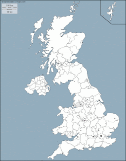
1º and 3º British: UK blank maps


It is not easy find a United Kigdom blank map on the book shops here, so you can download them with this map-file. You can print them in colour or black&white, as you prefer, before filling the political and physical items in the correct place. 

Remember that this work (the whole work, with the others maps too) is compulsory and must be given on Tuesday 4th of December.

miércoles, 19 de septiembre de 2012

4º British: Unit 2 English Parlamentarism


Here it is the first theoretical unit: The English Parlamentarism. One of the shorter's topics of the year (only 4 pages!).

martes, 18 de septiembre de 2012

4º British: Unit 1 Methodology


Here you have the link to the document: History: introduction and methodology. As I said, it is written in Spanish because they are the basic rules, and you will find them useful next year at Bachillerato, too.

Tomorrow, I will publish the first theoretical unit of this year... 


viernes, 14 de septiembre de 2012

3º British: Units and activities of the Historical part


As I said at class, there’s no text-book this year. Almost all the materials (theoretical units, questions for homework…) will be provided by this blog. You must download and print them at home, and bring them to class well-organissed in a ring-bilder. 

Here are the links for the theorical units of the Historical part:


  1. England in the 16th century.
  2. Spain and the Austrias Mayores.
  3. The Baroque Period. Art and culture.
  4. Europe in the 17thcentury.
And here the two weekly works of this part:

Picture-collage by DDR.

lunes, 10 de septiembre de 2012

Academic information 2012-2013


In the links below, students can read the academic information for this year:
You can also read more details about the Assesment criteria (Criterios de calificación).

viernes, 22 de junio de 2012

Muchas gracias!


Muchísimas gracias a tod@s por los regalos tan bonitos que me habéis hecho, ha sigo un gesto precioso y me ha emocionado mucho (alguna lagrimilla si que se me ha escapado…). Tenéis un corazón de oro, no cambiéis nunca!

Habéis sido unos alumnos estupendos, me ha encantado daros clase estos dos años, con todas las cosas buenas (las batallitas, las anécdotas de K. o de M., las risas, las actividades de Internet, las maquetas, los spaguettis…) y también con algún que otro sermón (eso también forma parte de la vida en un instituto, verdad?). Me llevo muchos buenos recuerdos (y anécdotas en mi cuaderno de gazapos, jeje). Yo también os echaré de menos, de verdad.

Os deseo lo mejor, dentro y fuera del instituto. Mucha suerte!

Cuidaros... y estudiad J

un abrazo

-- Adriana Carriles --

PD. Ya están todas las fotos publicadas! Podéis verlas debajo de este texto. Las pongo por orden “cronológico”, según me habéis ido dando los regalos. Creo que es lo más justo, para que nadie se sienta molesto, vale? Y, como veis, algunas fotos están pixeladas para que no se reconozcan vuestros nombres/caras.
PD.2. Hay una foto nueva, cuack! 


Despedida de 2ºB


Han sido dos años juntos, muchas horas de convivencia y conversaciones, y eso crea un vínculo. Pero nunca hubiera imaginado una respuesta tan bonita como la que habéis tenido; es algo que, además de lo emotivo del momento (llevaré esa pulsera tan especial siempre conmigo), anima a seguir esforzándose por hacer un buen trabajo. Aunque desde luego la mayor recompensa es ver vuestras caras al descubrir que una asignatura como la Historia puede ser divertida, y queriendo aprender más cosas!

Sois buenos, generosos y responsables, daros clase ha sido un lujo. Muchas gracias por todo. Tenéis un gran futuro por delante, os deseo todo lo mejor.

Siempre seréis “mis niñ@s”...

Despedida 3ºA


¡Qué sorpresa me habéis dado hoy! Mis últimas horas en el Mateo y vosotros habéis conseguido que sean muy especiales... Sois increíbles! Gracias! 

Y que sepáis que este pato (tengo que ponerle un nombre...) este verano se viene conmigo de vacaciones! Como el gnomo de la película Amèlie ;-) Ya os mandaré alguna foto. Cuack!


Ha sido el curso de 3º más divertido que he impartido nunca (y ya llevo unos pocos...). Muchas gracias por todo!

miércoles, 20 de junio de 2012

Despedida de I. y L. (3º)


Tenéis razón: os “debo” un curso… ¡Gracias por las flores!

Despedida de 2ºC


Nunca había recibido un ramo de flores tan bonito ni una caja de bombones tan ricos... Gracias!